Wednesday, September 28, 2011

Garnet Valley Dam


Garnet Valley Dam

Perhaps the easiest way to get to the Garnet Valley Dam is to head north on Victoria Road in Summerland. Continue right to the end and then turn left on Jones Flat road. Soon Jones Flat road swings north, joining Garnet Valley Road. From this junction it is about 6.4 kilometres of paved road and 3.6 kilometres unpaved road to the Garnet Valley Dam.

The first section passes many small farms and ranches. I did notice a wild peach tree, but even in mid-September the fruit was still small and hard. Perhaps some years they might size up or ripen but it does not look good for this year. The rock out-crops on the steep sides of this narrow valley clearly show the fragile nature of the soils on these hills. Near where the dirt road begins, the narrow valley becomes more of a canyon and the road twists and turns through the bottom. There is little sign of the creek that comes from the dam.

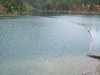
Reaching the dam I was disappointed that the area where we used to launch the boats and park was now fenced off. There were some access points through the fence, but a large man or a person with a canoe or boat would have a tough to access the lake. I carried on up a little hill and found a parking spot with a locked gate through which I could see a couple of picnic tables and some toilet facilities.

Here there was a better walkway through the fence, but it would still be rather awkward carrying a canoe through the narrow angled passage. There was a sign prohibiting swimming, campfires, barbeques, boat motors and ice fishing. It is sad that more reservoirs are becoming more restricted to public use. (If we all treat these areas with respect we will retain the privilege of using them in the future. Tread lightly and leave as faint a footprint as possible.) This area is bench land with lots of Jack Pine and is relatively flat, but the bank down to the lake is fairly steep for most part. the easiest place to launch a canoe would be to head back towards the dam as the slope here is gentler.

The southern section of the lake is steep on both the eastern and western shores. The western side is more rugged with some areas of broken rock slope. Towards the north there is a little better foreshore, but at the moment I’m not sure of public access via these roads.

I could not find a record of any recent stockings, but we used to catch brook trout here years ago. On my first cast this day I had two strikes, but that was all for the next half hour. Alas, all too soon I had to pack up my rod and leave for other duties. I would have liked to explore the shoreline towards the northern end where there are more shallows for the fish to feed. Perhaps next year I will find more time in the warmer weather.

Now with October upon us it's not quite time to put away the canoe and fly rods, but time to take out the guns and spinning outfit and explore more of the high country looking for those small out-of-the-way lakes while looking to fill the freezer with venison.

Now that all the wild walnuts are hulled, it’s time to re-sort the tackle box in the evenings and to make my backpack anchor bags, time to study the maps looking for those little out-of-the-way spots that need a little more fishing pressure. Yes, after 60-plus years there is still plenty to discover in these glorious hills.
Tuesday, September 20, 2011

Halloween Hike.


Halloween Hike

Ask our grown up children what Halloween stands out in their memories and it is not of the usual trick or treat scene, but of a Halloween hike up behind the Naramata reservoir.

We had decided the night before that rather than stay and home handing out treats to little ghosts and goblins; it would be a good chance for another grouse hunting trip. Leaving home just after lunch we would hunt until it got dark and then we would stop at A & W for a burger before going home. Each year as Halloween approaches, we remember this very spooky hike. Even today our kids in their thirty ’s fondly recall that particular hike.
 
Piling into the car after lunch, we drove to Naramata and there turned off on the Smethurst Road. This took us pass the Kettle Valley Rail line and up to the second level where we briefly investigated the rock ovens. Reaching the next level we took the old railway bed to Chute Lake. Here we turn off and headed up to the Reservoir.

Parking at the dam, we bundled up and head up in search of a little used road. There was a nip in the air and the leaves were still slowly swirling to the ground and were crunching under foot. I lead the way up the road twenty two ready listening both for birds and to the chatter of Annemarie, Michael and John as they trailed along with Tricia. I used to joke, that like a golfer this was my hunting handicap. The day was grey and we were now up in the clouds which diffuse what light there was.

The old road was nearly overgrown in places as is weaved through the thick growth of lodgepole pine. The low ground cover had an abundance of low bush huckleberry bushes. Several grouse come to scratch the banks of the old road were added to our pack sacks.

Several miles later, dusk began to fall fast so we headed back, a little disappointed that we had not found Big Meadow Lake. By now the kids grew quiet and we grew closer as a group. Fog drifted slowly and the lodgepole pines creaked somewhat eerily in the gathering darkness. Clouds allowed an occasional glimpse of the moon through some starkly bare poplar trees. A snowy owl glided silently over head for some reason keeping us company.

No need to tell ghost stories to set the mood, each creak of the trees and the hoots of the owl and the constant swirling of the fog had the kids a bit frightened and they were now hand and hand with my wife and I. Without a flashlight we slowly felt our way along the track back to the car.

The trip down the mountain was very quiet as I was concentrating on peering into the fog that at times cut the car lights distance to feet rather than yards. Checking the back set we found they were not sleeping, but sitting quietly but wide eyes looking into the fog.

At last we reached Penticton and made our way to A & W for the promised burgers. It was here that the kids began to talk and relive the hike.

Why not give the kids a different memory this year and take any old road in the thick bush and go for a Halloween hike. Hiking need not just be a warm weather sport. I haven’t been up this way since the fires, but the hiking/cross country trails up the Carmi Road or any of the old roads up this way make and excellent outing. Teach them to value the outdoors.

Tuesday, September 13, 2011

Tracking Snow

Tracking Snow

Hunting season is upon us and all die hard hunters long for those special days when we get a dusting of tracking snow. You know the fresh snow that is not too powdery, but that holds a track well. Less chance of an big game animal getting away wounded. But that’s another subject.

Years back when I was working at OK Welders Supplies, I worked with Bob C. (yeah another Bob), who talked a good hunt. Not having a regular hunting partner at the time, I figured why not go out with him.
Early in the predawn I pick him up at his hotel and we were out at Barslow Canyon just as it was beginning to get light. Sure enough the snow just stopped falling and we spotted some fresh tracks at the bottom of the loop. I back up off the road and we sat for a minute planning the hunt.

“You follow the tracks,” I said, “and I’ll keep a few hundred yards off to the side and follow you. When it tries to slip by you I should be in good position.”

Off Bob went and started up the hill following the tracks slowly ready for anything. I set of up the hill too, keeping my eyes on his progress through the breaks in the trees, keeping far enough distance to give the deer a chance to try to slip between us. After about half an hour, Bob starts circling a tree and looking up. Finally I had to find out what was up. “What’s going on Bob?” I called just loud enough for him to hear.
“It’s gone. Its disappeared” the call came back. Very strange I figured. So down through the little draw and to Bob’s side I went. Sure enough the tracks ended up in the bare patch under the large Douglas Fir. A quick look at the tracks revealed why though. Bob had been tracking the deer backwards to where it had bedded down for the night.

Remember, even with the good tracking snow to keep a keen eye on the tracks and good luck this season.

Thursday, September 8, 2011

Upper Clarke Lakes

Towards the South end of Upper Clarke Lake #2

North End of Upper Clarke Lake #2

South End of Upper Clarke Lake #3

North End of Upper Clarke Lake #3

Upper Clark Lakes

I was off to explore the Upper Clark Lakes and made a real amateur blunder. It was hot and with my bad back I thought I would really reduce my pack and leave my net at home. Hadn’t I heard that they were all small fish here anyhow?

Now, I was perched on a log along the muddy shore at Upper Clark Lake 2 with a nice rainbow trout nearly 40 centimetres in length. For about ten heart-stopping minutes, it lept and ran my line out before I was able to bring it to hand to lift it onto shore. None to soon, for as I lifted it the hook slipped from its jaw and I dropped it into the weeds. I quickly dispatched it, clean it of innards and gills and put it on ice to show my wife when I got home. In this hot weather it is important not to let such a prize spoil.

Over the next half hour I manage to play and release a couple more fish that were slightly smaller, however there was no shade here and the heat was getting to me. Time to move on and check out Upper Clark Lake 3.

Half an hour later I was repeating this scenario on Upper Clarke Lake 3, only this time I was on a fairly steep shoreline. Again a nice rainbow trout was quickly dispatched and put on ice. Over the next hour with a little more shade, I landed about 8 more fish between 20 and 40 centimetres length, but all were spawners and were gently release back into the water.

Both of these lakes are fairly easy to reach. Take the Weyerhaeuser 201 Road from Okanagan Falls for roughly 22 kilometres, past the Allendale Lake Road and cabin on the right hand side. The road to the Upper Clark Lakes is off to the right and just past it the road to Lower Clark Lake heads off to the left. I like to park here and hike to the Upper Clark Lakes, but it is possible to drive the fairly rough road to them, although there are a few wet and muddy sections.

Parking here I take the first road to the right and then keep to the left. At about 400 metres the road splits and there is a little creek and dam. This is Upper Clark Lake 2, a little smaller than it was when the dam was fully functional. Now most of the shoreline is shallow grass and muddy with some old snags here and there. It is rather shallow even at the north end where there is a large steep rock outcropping. The annual stocking appears to be 1000 rainbow trout and there is obviously a good survival rate and some nice fish here.
It was another 280 metres down the road on the west side of the lake to reach the end where I checked out the waters beneath the rock outcrop. This was where I landed the nice fish.

About 1.2 kilometres further up the road you reach Upper Clark Lake 3. It is nothing like first lake. It is much larger, appears to be quite deep, the sides are mainly quite steep and it is treed right to the water’s edge. It is reasonably easy to fish from shore, but it would not be to hard too carry a light canoe into this lake. Again records show over the last few years an annual stocking of 1000 rainbow trout. From the banks it was possible to watch lots of large trout cruising around, I’ll definitely hike the canoe in here when I’m feeling better.